Texas Prepares for Wintry Blast of Snow, Sleet, and Freezing Rain

Texans are preparing for a severe winter storm that is set to envelop the entire state in subfreezing temperatures starting Friday. An arctic mix of snow, sleet, and freezing rain is on the horizon.
Frigid air is sweeping in from northern Canada, with National Weather Service Meteorologist Kurt Van Speybroeck indicating that it will reach the southernmost tip of Texas by Sunday morning.
Residents from Wichita Falls to Lubbock and Amarillo should brace for snowy conditions late Friday. The cold air and precipitation are expected to push southward on Saturday, with temperatures in Brownsville expected to drop below freezing by Sunday morning. A hard freeze will affect every corner of the state, from El Paso to the Houston area, according to Speybroeck.
“By Sunday, the entire state will be experiencing well-below normal temperatures and dangerous wind chills,” Speybroeck noted. He also warned of a significant chance of ice across much of Texas, which could lead to power outages.
“We’re looking at two-thirds to three-quarters of the state facing hazardous winter driving conditions,” he added, although he reassured that “everything south of I-10 should be drivable.”
Officials in North and Central Texas, where the likelihood of snow and sleet is highest, have already issued winter storm watches. Houston and other areas are also under similar advisories.
Governor Greg Abbott announced on Tuesday that state emergency response resources have been activated, emphasizing that the winter weather “could create hazardous travel conditions into the weekend and impact infrastructure.”
Here’s what Texans can expect based on their location:
The Panhandle
The Panhandle is predicted to face the brunt of the storm on Friday night, with temperatures plummeting to 2 degrees and a 90% chance of precipitation.
“That will quickly transition to snow, which will be fairly dry and fluffy,” Speybroeck explained, cautioning that wind could impair visibility while driving.
The storm is expected to shift further south Friday night into Saturday morning.
Dallas-Fort Worth Area
The Dallas-Fort Worth region is likely to experience freezing rain and sleet accumulating Friday night, with some areas possibly seeing snow by Saturday evening, according to the NWS.
Cities north of Dallas-Fort Worth, from Graham to Paris, should anticipate the heaviest snowfall.
The coldest temperatures in the area are expected Saturday night, dipping to 10 degrees, with a high of only 22 degrees on Sunday.
Central Texas
Central Texans can also expect sleet and freezing rain, although Speybroeck noted that heavy accumulations are less likely compared to North Texas.
“We’re anticipating sleet and freezing rain in the Hill Country and possibly into the Austin-San Antonio corridor, but significant winter precipitation is not expected,” he said.
Temperatures in Central Texas could drop to as low as 14 degrees on Saturday night.
El Paso and Far West Texas
El Paso may see snow as early as Friday morning, with accumulations potentially reaching up to 10 inches during the storm.
Wind gusts could reach 22 miles per hour on Saturday, making driving conditions treacherous.
While El Paso is likely to receive snow, temperatures are not expected to plummet as low as in other regions, with Saturday night lows around 28 degrees, rising to 41 on Sunday.
Temperatures are forecasted to dip back below freezing on Sunday night.
Houston Region
The Houston area faces a high chance of rain and thunderstorms Friday night into Saturday morning. By Saturday night, this is expected to transition to freezing rain, with a low of 27 degrees, according to the NWS.
Rain is anticipated to continue throughout Saturday, turning into freezing rain overnight into Sunday morning, when temperatures are expected to drop below freezing. Partly sunny conditions should return on Monday, bringing temperatures above freezing.
South Texas
By Sunday morning, the winter storm is projected to reach the southern tip of Texas.
Residents from Laredo to Brownsville should prepare for temperatures hovering around freezing as Sunday transitions into Monday.
The coldest temperatures are expected Saturday and Sunday nights, with lows around 33 degrees and a slight chance of light rain.
This article first appeared on The Texas Tribune.
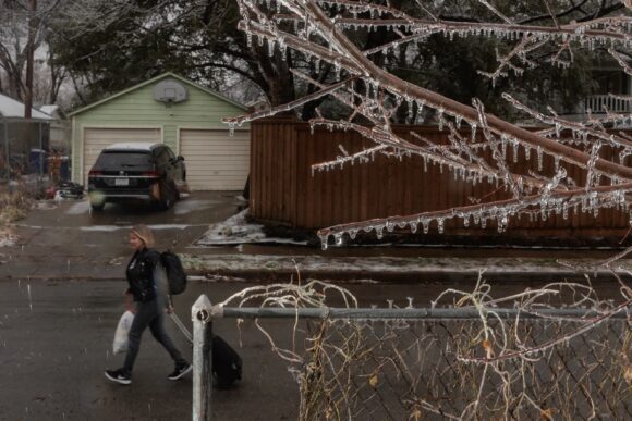
Photo: Amber Hamilton walks to her car to drive to the airport after waiting through two days of flight cancellations due to icy conditions in Dallas on Feb. 2, 2023. Shelby Tauber for The Texas Tribune
Topics
Texas
Texans are preparing for a severe winter storm that is set to envelop the entire state in subfreezing temperatures starting Friday. An arctic mix of snow, sleet, and freezing rain is on the horizon.
Frigid air is sweeping in from northern Canada, with National Weather Service Meteorologist Kurt Van Speybroeck indicating that it will reach the southernmost tip of Texas by Sunday morning.
Residents from Wichita Falls to Lubbock and Amarillo should brace for snowy conditions late Friday. The cold air and precipitation are expected to push southward on Saturday, with temperatures in Brownsville expected to drop below freezing by Sunday morning. A hard freeze will affect every corner of the state, from El Paso to the Houston area, according to Speybroeck.
“By Sunday, the entire state will be experiencing well-below normal temperatures and dangerous wind chills,” Speybroeck noted. He also warned of a significant chance of ice across much of Texas, which could lead to power outages.
“We’re looking at two-thirds to three-quarters of the state facing hazardous winter driving conditions,” he added, although he reassured that “everything south of I-10 should be drivable.”
Officials in North and Central Texas, where the likelihood of snow and sleet is highest, have already issued winter storm watches. Houston and other areas are also under similar advisories.
Governor Greg Abbott announced on Tuesday that state emergency response resources have been activated, emphasizing that the winter weather “could create hazardous travel conditions into the weekend and impact infrastructure.”
Here’s what Texans can expect based on their location:
The Panhandle
The Panhandle is predicted to face the brunt of the storm on Friday night, with temperatures plummeting to 2 degrees and a 90% chance of precipitation.
“That will quickly transition to snow, which will be fairly dry and fluffy,” Speybroeck explained, cautioning that wind could impair visibility while driving.
The storm is expected to shift further south Friday night into Saturday morning.
Dallas-Fort Worth Area
The Dallas-Fort Worth region is likely to experience freezing rain and sleet accumulating Friday night, with some areas possibly seeing snow by Saturday evening, according to the NWS.
Cities north of Dallas-Fort Worth, from Graham to Paris, should anticipate the heaviest snowfall.
The coldest temperatures in the area are expected Saturday night, dipping to 10 degrees, with a high of only 22 degrees on Sunday.
Central Texas
Central Texans can also expect sleet and freezing rain, although Speybroeck noted that heavy accumulations are less likely compared to North Texas.
“We’re anticipating sleet and freezing rain in the Hill Country and possibly into the Austin-San Antonio corridor, but significant winter precipitation is not expected,” he said.
Temperatures in Central Texas could drop to as low as 14 degrees on Saturday night.
El Paso and Far West Texas
El Paso may see snow as early as Friday morning, with accumulations potentially reaching up to 10 inches during the storm.
Wind gusts could reach 22 miles per hour on Saturday, making driving conditions treacherous.
While El Paso is likely to receive snow, temperatures are not expected to plummet as low as in other regions, with Saturday night lows around 28 degrees, rising to 41 on Sunday.
Temperatures are forecasted to dip back below freezing on Sunday night.
Houston Region
The Houston area faces a high chance of rain and thunderstorms Friday night into Saturday morning. By Saturday night, this is expected to transition to freezing rain, with a low of 27 degrees, according to the NWS.
Rain is anticipated to continue throughout Saturday, turning into freezing rain overnight into Sunday morning, when temperatures are expected to drop below freezing. Partly sunny conditions should return on Monday, bringing temperatures above freezing.
South Texas
By Sunday morning, the winter storm is projected to reach the southern tip of Texas.
Residents from Laredo to Brownsville should prepare for temperatures hovering around freezing as Sunday transitions into Monday.
The coldest temperatures are expected Saturday and Sunday nights, with lows around 33 degrees and a slight chance of light rain.
This article first appeared on The Texas Tribune.
Photo: Amber Hamilton walks to her car to drive to the airport after waiting through two days of flight cancellations due to icy conditions in Dallas on Feb. 2, 2023. Shelby Tauber for The Texas Tribune
Topics
Texas