Experts Alert: ‘Potentially Catastrophic’ Storm Threatens Southern Regions

As many Americans continue to recover from a series of snowstorms and relentless freezing temperatures in the northern regions, a new storm is poised to strike this weekend. This impending weather system could blanket roads, trees, and power lines with hazardous ice across a broad swath of the South.
According to Ryan Maue, a former chief scientist at the National Oceanic and Atmospheric Administration, the storm, which is expected to arrive late this week and continue into the weekend, is likely to be a “widespread potentially catastrophic event from Texas to the Carolinas.”
“I don’t know how people are going to deal with it,” Maue remarked, highlighting the severity of the situation.
Forecasters have issued warnings that the ice accumulation could weigh down trees and power lines, leading to widespread outages. Keith Avery, CEO of the Newberry Electric Cooperative in South Carolina, emphasized the potential danger: “If you get a half of an inch of ice — or heaven forbid an inch of ice — that could be catastrophic.”
Heavy Snow, Sleet, and Freezing Rain Expected
The National Weather Service has alerted the public to anticipate “great swaths of heavy snow, sleet, and treacherous freezing rain” beginning Friday across much of the midsection of the nation, with the storm shifting toward the East Coast by Sunday.
Temperatures are expected to rise slowly in many areas, meaning that any ice that forms on roads and sidewalks may linger, according to forecasters. The exact timing and trajectory of the storm remained uncertain as of Tuesday, complicating predictions about which areas will experience rain versus those that will face ice.
An extremely cold arctic air mass is set to plunge south from Canada, colliding with cold temperatures and rain moving eastward across the southern U.S. “This is extreme, even for this being the peak of winter,” noted National Weather Service meteorologist Bryan Jackson.
When the cold air meets the rain, forecasters predict a “major winter storm with very impactful weather,” fueled by moisture streaming in from the Gulf. An atmospheric river of moisture could develop by the weekend, transporting precipitation across Texas and other Gulf Coast states, continuing into Georgia and the Carolinas.
“Global models are painting a concerning picture of what this weekend could look like, with an increasingly strong signal for ice storm potential across North Georgia and portions of central Georgia,” the National Weather Service’s Atlanta office reported.
If significant ice accumulations occur in metro Atlanta, the situation could remain problematic through the weekend, as low temperatures early Monday are expected to hover around 22 degrees Fahrenheit (minus 5.6 degrees Celsius), with a high of approximately 35 degrees Fahrenheit (1.7 degrees Celsius).
Travel poses a significant concern, particularly since southern states typically have fewer resources for snow and ice removal. The extremely cold temperatures expected after the storm could prevent ice from melting for several days. In Michigan, over 100 vehicles crashed into each other or slid off an interstate southwest of Grand Rapids on Monday.
The storm is also anticipated to disrupt operations at several major hub airports, including those in Dallas, Atlanta, Memphis, Tennessee, and Charlotte, North Carolina.
While unusually cold temperatures are already prevalent across much of the northern U.S., the arctic air blast expected later this week is predicted to be the coldest yet. “There’s a large sprawling vortex of low pressure centered over Hudson Bay,” Jackson explained, referring to the sea in northern Canada connected to the Arctic Ocean. “And this is dominating the weather over all of North America.”
Some of the storm’s earliest impacts could be felt in Texas on Friday as the arctic air mass moves southward across much of the state, according to National Weather Service forecaster Sam Shamburger.
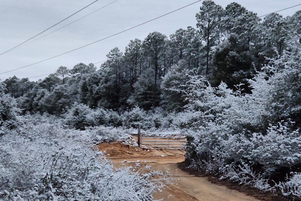
Photo: Parts of the Florida Panhandle already saw some snow this month, including Holt, on Jan. 18. (Danielle Brahier via AP)
Copyright 2026 Associated Press. All rights reserved. This material may not be published, broadcast, rewritten, or redistributed.
Topics
Catastrophe
Windstorm
Interested in Catastrophe?
Get automatic alerts for this topic.
As many Americans continue to recover from a series of snowstorms and relentless freezing temperatures in the northern regions, a new storm is poised to strike this weekend. This impending weather system could blanket roads, trees, and power lines with hazardous ice across a broad swath of the South.
According to Ryan Maue, a former chief scientist at the National Oceanic and Atmospheric Administration, the storm, which is expected to arrive late this week and continue into the weekend, is likely to be a “widespread potentially catastrophic event from Texas to the Carolinas.”
“I don’t know how people are going to deal with it,” Maue remarked, highlighting the severity of the situation.
Forecasters have issued warnings that the ice accumulation could weigh down trees and power lines, leading to widespread outages. Keith Avery, CEO of the Newberry Electric Cooperative in South Carolina, emphasized the potential danger: “If you get a half of an inch of ice — or heaven forbid an inch of ice — that could be catastrophic.”
Heavy Snow, Sleet, and Freezing Rain Expected
The National Weather Service has alerted the public to anticipate “great swaths of heavy snow, sleet, and treacherous freezing rain” beginning Friday across much of the midsection of the nation, with the storm shifting toward the East Coast by Sunday.
Temperatures are expected to rise slowly in many areas, meaning that any ice that forms on roads and sidewalks may linger, according to forecasters. The exact timing and trajectory of the storm remained uncertain as of Tuesday, complicating predictions about which areas will experience rain versus those that will face ice.
An extremely cold arctic air mass is set to plunge south from Canada, colliding with cold temperatures and rain moving eastward across the southern U.S. “This is extreme, even for this being the peak of winter,” noted National Weather Service meteorologist Bryan Jackson.
When the cold air meets the rain, forecasters predict a “major winter storm with very impactful weather,” fueled by moisture streaming in from the Gulf. An atmospheric river of moisture could develop by the weekend, transporting precipitation across Texas and other Gulf Coast states, continuing into Georgia and the Carolinas.
“Global models are painting a concerning picture of what this weekend could look like, with an increasingly strong signal for ice storm potential across North Georgia and portions of central Georgia,” the National Weather Service’s Atlanta office reported.
If significant ice accumulations occur in metro Atlanta, the situation could remain problematic through the weekend, as low temperatures early Monday are expected to hover around 22 degrees Fahrenheit (minus 5.6 degrees Celsius), with a high of approximately 35 degrees Fahrenheit (1.7 degrees Celsius).
Travel poses a significant concern, particularly since southern states typically have fewer resources for snow and ice removal. The extremely cold temperatures expected after the storm could prevent ice from melting for several days. In Michigan, over 100 vehicles crashed into each other or slid off an interstate southwest of Grand Rapids on Monday.
The storm is also anticipated to disrupt operations at several major hub airports, including those in Dallas, Atlanta, Memphis, Tennessee, and Charlotte, North Carolina.
While unusually cold temperatures are already prevalent across much of the northern U.S., the arctic air blast expected later this week is predicted to be the coldest yet. “There’s a large sprawling vortex of low pressure centered over Hudson Bay,” Jackson explained, referring to the sea in northern Canada connected to the Arctic Ocean. “And this is dominating the weather over all of North America.”
Some of the storm’s earliest impacts could be felt in Texas on Friday as the arctic air mass moves southward across much of the state, according to National Weather Service forecaster Sam Shamburger.
Photo: Parts of the Florida Panhandle already saw some snow this month, including Holt, on Jan. 18. (Danielle Brahier via AP)
Copyright 2026 Associated Press. All rights reserved. This material may not be published, broadcast, rewritten, or redistributed.
Topics
Catastrophe
Windstorm
Interested in Catastrophe?
Get automatic alerts for this topic.